Ancient · Quintana Roo · Maya (Yucatec) · Late Postclassic, c. 1200 to 1521 CE
Tulum
A walled Maya port on a limestone cliff above the Caribbean, and one of the last Maya cities still lived in when Spanish ships first passed by.
Federally protected archaeological zone administered by INAH, within Tulum National Park
Tulum is the Maya city that everyone photographs and few slow down to read. It stands on a low limestone cliff above the Caribbean, a walled port that traded jade and obsidian along the coast and outlived most other Maya cities. It was still standing when Spanish ships first passed by in 1518.
The story
The Maya knew this place as Zama. It rose during the Late Postclassic, after about 1200, when many of the great inland cities had already faded, and it became one of the coast's main ports.
Its people were still living here when Juan Díaz, sailing with the Grijalva expedition in 1518, recorded a walled town from the deck of a Spanish ship. Within a few generations the population collapsed under conquest and disease, and the city was left empty by the end of the 1500s.
What you are looking at
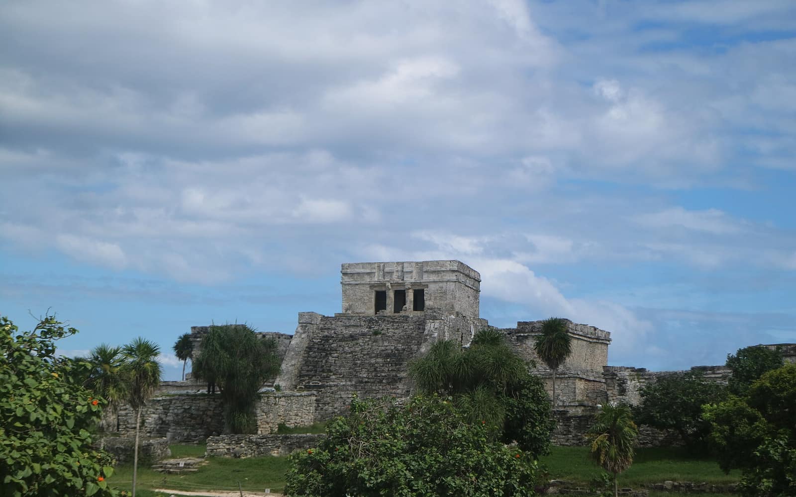
The site is a compact cluster of gray limestone buildings on a bluff above turquoise water. A low wall runs along three landward sides, between three and five meters high and roughly 400 meters along its longest stretch, with gateways and two corner structures often read as watchtowers.
The tallest building is El Castillo, a stepped temple at the cliff edge. Nearby stand the Temple of the Frescoes and the Temple of the Descending God, both named for the art they carry.
Why it was sacred
Tulum's carvings return again and again to a winged figure shown diving head first from above, the deity now called the Descending God or Diving God. Its exact meaning is still debated, with links proposed to Venus, the setting sun, and bees.
By tradition the town was also a place of pilgrimage tied to Ixchel, a Maya goddess associated with the moon, water, and childbirth. Small shrines and the murals of the Temple of the Frescoes, painted with rain gods, serpents, and offerings, point to a busy ceremonial life behind the trade.
A port on the sea road
Tulum sat on a coastal trade network that moved goods by canoe between the Gulf of Honduras and the northern Yucatán. Obsidian recovered here was traced to the Ixtepeque source in highland Guatemala, close to 700 km away, a measure of how far the routes reached.
A gap in the cliff gave canoes a landing below the town, and El Castillo's position facing the water may have helped crews find it. The trade in jade, obsidian, salt, cotton, and other goods is what kept the port alive well into the Postclassic.
Standing there today
The ruins draw more than two million visitors a year, which makes the modern name a little misleading. The Maya called it Zama, dawn; today Tulum names both the ancient port and the beach town that grew up beside it, and the two are easy to confuse.
Come early and the light is low, iguanas sun themselves on the stone, and the sea is loud below the cliff. Come at midday and you share the paths with the crowds. Either way the buildings are roped off, so the visit is about looking, not climbing.
Did you know
- The modern name Tulum means wall in Yucatec Maya, while the older name Zama is usually read as dawn, fitting a city that faces the sunrise.
- Tulum is one of the few Maya cities built with a defensive wall, which guards it on three landward sides while the sea protects the fourth.
- El Castillo stands on a 12 m cliff, and some researchers think its position also helped guide trading canoes through gaps in the offshore reef.
- Obsidian found at Tulum was traced to the Ixtepeque source in highland Guatemala, close to 700 km away.
- When John Lloyd Stephens and Frederick Catherwood documented the site in the 1840s, they helped introduce Maya ruins to a wide English-reading public.
- The Temple of the Frescoes keeps some of the best-preserved Maya wall paintings on the Caribbean coast, in the Mixteca-Puebla style.
- Tulum is the third most-visited archaeological site in Mexico, after Teotihuacán and Chichén Itzá.
Through time
- 564 CE A date carved on Stela 1, the earliest known inscription linked to the site.
- c. 1200 CE Tulum rises as a walled port during the Late Postclassic.
- 1518 Juan Díaz, with the Grijalva expedition, records the town from the sea, the first European account.
- late 1500s The city is abandoned in the century after Spanish contact.
- 1840s Stephens and Catherwood survey and publish the ruins for a wide audience.
- 2024 The site is incorporated into the Parque del Jaguar reserve.
Before you go
The ruins sit just north of Tulum town on Highway 307, about two hours south of Cancún. Colectivos, taxis, and tour buses run from town and the Riviera Maya, and the new Maya Train also reaches Tulum.
Arrive at opening, around eight in the morning, to beat both the heat and the tour crowds. The site is fully exposed with almost no shade.
Ninety minutes to two hours covers the walled core at an unhurried pace.
Stay on the marked paths and do not climb the structures, which are roped off to protect the stone and murals. Bring water and sun protection.
Sources: Wikipedia, Tulum · INAH, Zona Arqueológica de Tulum · INAH Lugares, Tulum · CONANP, Tulum National Park
Nearby & related
The vast city of pyramids the Aztecs later called “the place where the gods were created.”
Ancient · State of México Chichén ItzáThe Maya city whose pyramid still catches the equinox serpent of light on its steps.
Ancient · Yucatán Monte AlbánA Zapotec capital levelled from a ridge-top, floating above the valley of Oaxaca.
Ancient · Oaxaca PalenqueThe rainforest Maya city of Pakal, where fine stone temples meet the jungle canopy.
Ancient · Chiapas UxmalA Late Classic Maya capital in the dry Puuc hills, its limestone palaces covered in masks of the rain god Chaac.
Ancient · YucatánHold ceremony in Mexico?
Each vertical opens with a curation round: verified, or not listed. Tell us who you are, what you hold, and where we can check you.
For practitioners →